Iconic Landscapes
Canada’s iconic landscapes represent some of the most geographically diverse and visually striking terrain on Earth. From the jagged peaks of the Canadian Rockies to the world’s highest tides in the Bay of Fundy, from the endless expanse of prairie skies to the ethereal dance of the northern lights, these natural wonders draw millions of visitors annually while demanding thoughtful preparation and respect. Understanding what makes each landscape unique—and the practical considerations that come with accessing them—transforms a casual visit into a meaningful, safe, and rewarding experience.
This comprehensive resource introduces you to Canada’s most celebrated natural environments, examining not just their visual appeal but the seasonal patterns, logistical challenges, safety protocols, and cultural contexts that define each region. Whether you’re planning your first mountain road trip, curious about cottage country traditions, or preparing to photograph the aurora borealis, the following sections provide the foundational knowledge needed to appreciate these landscapes responsibly and thoroughly.
Mountain Majesty: Rockies and Glacial Terrain
The Canadian Rockies constitute one of the world’s most accessible mountain ranges, yet their beauty belies significant planning requirements. The region’s dramatic elevation changes, unpredictable weather patterns, and wildlife populations create a complex environment where timing, preparation, and awareness are essential.
Seasonal Dynamics and Wildlife Considerations
The Rockies operate on a compressed seasonal calendar that fundamentally shapes visitor experiences. Peak summer months (July and August) offer maximum daylight—up to 16 hours in some areas—and reliably open mountain passes, but also bring premium accommodation rates that can increase by 40-60% compared to shoulder seasons. Conversely, the shoulder periods of late May-June and September-October present moderate weather risks including sudden snowfall at higher elevations, but reward visitors with fewer crowds and more accessible wildlife viewing as animals move to lower elevations during migration patterns.
Understanding wildlife hibernation cycles adds another layer to trip timing. Grizzly and black bears emerge from dens typically in April and remain active until late October or early November, requiring visitors to carry bear spray and practice food storage protocols. Parks Canada mandates bear-proof containers in backcountry areas, and regulations require maintaining a minimum distance of 100 meters from bears and 30 meters from other large mammals like elk and mountain goats.
Winter Driving and Mountain Road Safety
Winter mountain driving represents one of the region’s most underestimated challenges. Highway conditions can deteriorate rapidly, and the Trans-Canada Highway through Rogers Pass experiences periodic closures for avalanche control. Essential preparations include:
- Winter tire requirement: Mandatory on most British Columbia mountain highways from October through March
- Emergency supplies including blankets, non-perishable food, and a full-size spare tire
- Fuel planning for stretches like the Icefields Parkway, where services span 230 kilometers between stops
- Park pass acquisition before arrival, as some entry stations have limited payment options
Cellular connectivity disappears entirely on many mountain routes, making downloaded maps and offline navigation tools non-negotiable. The stretch between Lake Louise and Jasper, while breathtaking, offers virtually no reliable cell service for the entire 232-kilometer journey.
Glacial Environments and Climate Realities
Canada’s accessible glacial landscapes, particularly the Columbia Icefield, provide rare opportunities to witness ice age remnants firsthand, but they also serve as stark indicators of climate change. The Athabasca Glacier has receded approximately 1.5 kilometers over the past century, with markers along the approach trail documenting the retreat in sobering detail.
Visiting these environments safely requires understanding that glacial terrain creates its own micro-climate. Temperatures can drop 10-15 degrees Celsius compared to valley floors, and sudden weather changes occur with minimal warning. The Columbia Icefield Skywalk, a glass-floored observation platform extending over the Sunwapta Valley, offers spectacular views while highlighting the hydrological significance of these ice fields—meltwater from the Columbia Icefield flows to three different oceans via distinct river systems.
Unguided glacier access carries severe risks including crevasses, unstable ice, and hypothermia. Commercial guided tours provide proper equipment and expertise, representing the only responsible way for most visitors to step onto glacial ice.
Coastal Drama: Tidal Wonders of the Maritimes
The Bay of Fundy’s tidal phenomena create one of Earth’s most dynamic coastal environments, where the difference between high and low tide reaches up to 16 meters—equivalent to a four-story building. This dramatic tidal range creates unique ecosystems, sculptural rock formations, and access challenges that demand precise timing.
Understanding Tidal Mechanics
The Bay of Fundy’s extraordinary tides result from resonance—the bay’s length and depth create a natural period that matches the 12.4-hour tidal cycle, amplifying tidal movement. This creates a six-hour window during which approximately 160 billion tonnes of seawater flows in and out of the bay.
For visitors, this means scheduling activities around tide tables published by the Canadian Hydrographic Service. Many signature experiences are only accessible during specific tidal windows:
- Walking on the ocean floor at Hopewell Rocks is only possible during the two hours surrounding low tide
- Kayaking among flowerpot rock formations requires high tide when water levels reach 10+ meters
- Tidal bore rafting on the Shubenacadie River depends on incoming tide timing and lunar cycles
Terrain Challenges and Safety Protocols
The intertidal zone’s red mud and sediment create challenging terrain conditions. This fine, clay-based mud can be knee-deep in places and extremely slippery, making appropriate footwear essential—rubber boots with good tread are strongly recommended over hiking shoes. The remoteness of some coastal cliff viewpoints also demands caution, as rescue access is limited and tidal waters create changing hazards throughout the day.
Lakes, Cottages and Waterfront Culture
Canada’s cottage country, particularly concentrated in Ontario’s Muskoka, Haliburton, and Kawartha regions, represents a distinct cultural phenomenon where seasonal waterfront living shapes family traditions and regional economies. Understanding this culture’s nuances helps visitors navigate rental markets and manage expectations.
Regional Differences and Market Navigation
Not all cottage regions offer identical experiences. Muskoka commands premium prices and attracts a more developed tourism infrastructure, while Haliburton offers quieter, more remote lake access often at lower price points. The Kawarthas feature interconnected waterways ideal for extended boating trips but require understanding lock systems and navigation rules.
The cottage rental market operates on weekly bookings during peak season (late June through August), with many properties requiring Saturday-to-Saturday stays and advance booking six months to a year ahead. Rates typically include property access but not necessarily boats, which may be rented separately or require bringing your own trailer.
Boating Regulations and Waterfront Realities
Operating watercraft in Canada requires understanding federal and provincial regulations. The Pleasure Craft Operator Card is mandatory for anyone operating a motorized boat, requiring completion of an accredited boating safety course. Additional considerations include:
- Required safety equipment: lifejackets for all passengers, sound-signaling device, navigation lights, fire extinguisher for boats with inboard engines
- Blood alcohol limits that apply on water identical to road regulations (0.08% criminal limit)
- Speed restrictions in proximity to shores and designated swimming areas
Wildlife annoyances represent another cottage reality. Black flies and mosquitoes peak in May and June, while wasps become more aggressive in late summer. Raccoons, skunks, and occasionally black bears visit properties where food waste isn’t properly secured. Water safety risks include sudden depth changes, submerged obstacles, and cold water temperatures—even in summer, many Canadian lakes remain cold enough to cause cold water shock.
Prairie Horizons and the Big Sky
The Canadian prairies—spanning southern Saskatchewan, Alberta, and Manitoba—offer a landscape defined more by absence than presence. This vast openness creates the celebrated “Big Sky” phenomenon where the horizon appears endless and weather systems become visible hours before their arrival. For travelers accustomed to visual landmarks and frequent services, prairie driving demands psychological adjustment.
Long-distance prairie routes often span 100+ kilometers between services, creating legitimate fuel anxiety that requires planning. The Trans-Canada Highway between Swift Current and Medicine Hat exemplifies this challenge—limited services across nearly 300 kilometers. Summer weather brings its own considerations, including severe thunderstorms and occasional tornadoes, particularly in June and July when warm, moist air collides with dry continental systems.
Small towns along prairie routes offer more than just fuel stops—they provide windows into agricultural heritage through grain elevator museums, farmers’ markets, and historic main streets. Taking time to connect with these communities transforms monotonous driving into cultural exploration, revealing the landscapes that produce much of Canada’s wheat, canola, and pulse crops.
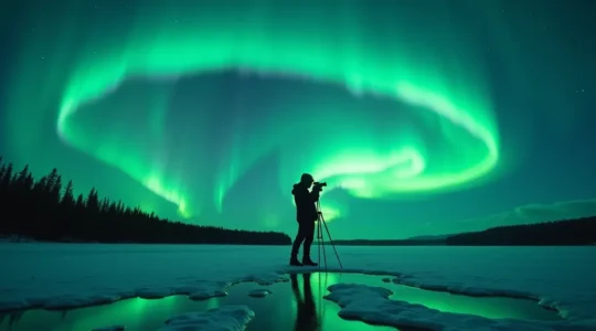
Celestial Theatre: Capturing the Northern Lights
The aurora borealis transforms Canada’s northern skies into shifting curtains of green, red, and purple light, but witnessing and photographing this phenomenon requires understanding both the science and the technical challenges involved.
Understanding Aurora Conditions
The KP index measures geomagnetic activity on a scale from 0-9, with higher numbers indicating stronger auroral displays visible at lower latitudes. A KP index of 5 or higher can make the aurora visible from southern Canadian provinces, while northern regions like Yukon, Northwest Territories, and Nunavut see displays regularly at KP 2-3. Space weather forecasting services provide 27-day outlooks and three-day predictions, though auroral activity remains notoriously difficult to predict with precision.
Clear, dark skies are essential—light pollution from cities diminishes or eliminates aurora visibility. The period from late August through April offers the longest dark hours, though auroral activity occurs year-round. Winter viewing means managing extreme cold that affects both photographers and equipment.
Technical Photography Considerations
Capturing auroral displays successfully requires specific equipment and techniques:
- Lens choice: Wide-angle lenses (14-24mm) with fast apertures (f/2.8 or wider) capture maximum sky and allow shorter exposures
- Stabilization: Sturdy tripods are mandatory for exposures ranging from 5-25 seconds
- Battery management: Cold temperatures drain batteries rapidly; carrying 3-4 fully charged spares and keeping them warm in interior pockets is essential
- Manual settings: Auto-focus and auto-exposure fail in dark conditions; manual focus set to infinity and manual exposure control are required
Composition techniques balance foreground elements—trees, buildings, ice formations—with auroral displays, creating context and scale. Leading lines draw viewers’ eyes from ground elements toward the sky, while rule-of-thirds placement prevents centered, static compositions.
Logistics and Access for Iconic Sites
Canada’s most celebrated natural sites face increasing visitation pressure, leading to mandatory reservation systems, shuttle services, and seasonal access windows that require advance planning.
Shuttle Systems and Alternative Transport
High-demand locations like Moraine Lake in Banff National Park now operate mandatory shuttle systems during peak summer hours (typically 6am-7pm) when parking lots fill to capacity. These Parks Canada shuttles require advance booking, often selling out weeks ahead for peak season dates. Understanding when shuttle requirements apply—and when private vehicle access remains possible—can determine whether you successfully reach iconic viewpoints.
Private transport alternatives include guided tours, which bundle transportation with interpretation, and early morning or evening visits outside mandatory shuttle hours. Some visitors opt for bicycle access on routes where parking is restricted but bike entry remains permitted.
Seasonal Windows and Alternative Destinations
Many iconic sites have limited seasonal access due to weather conditions. The Icefields Parkway typically opens fully in late May, though snow can linger into June. Conversely, some experiences like the Columbia Icefield Skywalk close entirely from mid-October through April.
Exploring alternative destinations reduces crowding while offering equally compelling experiences. While Lake Louise draws massive crowds, nearby Lake Agnes or Plain of Six Glaciers trails provide spectacular scenery with significantly fewer visitors. In coastal regions, exploring lesser-known sections of the Bay of Fundy coastline reveals dramatic geology without the tour buses present at Hopewell Rocks.
Successfully experiencing Canada’s iconic landscapes requires balancing spontaneity with preparation, understanding that these environments operate on natural rhythms indifferent to human schedules. The rewards—standing before ancient glaciers, feeling tidal waters surge around your kayak, or watching auroral curtains shimmer across prairie skies—justify the planning required. Each landscape offers not just visual spectacle but connection to geological processes, ecological systems, and cultural traditions that define Canadian identity. With proper preparation and realistic expectations, these iconic environments become accessible windows into the natural forces that continue to shape this vast nation.
Shooting the Aurora: What Camera Settings Capture the Green Without Noise?
In summary: Your primary enemy is lack of light. Use a lens with at least an f/2.8 aperture and a camera capable of clean images at ISO 1600-3200. Extreme cold is your second enemy. It drains batteries and can freeze…
Read more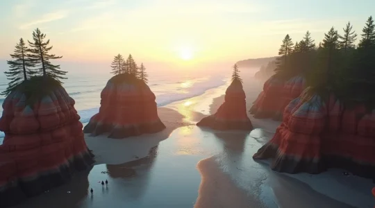
Hopewell Rocks Tides: How to Walk the Ocean Floor Without Getting Trapped?
The secret to safely experiencing Hopewell Rocks isn’t just checking a tide chart; it’s understanding the predictable physics that govern the Bay of Fundy’s rhythm. The tide doesn’t rise evenly. The fastest rise occurs in the 3rd and 4th hours…
Read more
Beyond the Horizon: How to Truly Experience the 800km Drive Across the Prairies
The drive across the Canadian Prairies isn’t an obstacle to be survived with good playlists; it’s a unique environmental experience to be embraced. The “emptiness” is actually a stage for Canada’s most dramatic weather and sunsets, a concept known as…
Read more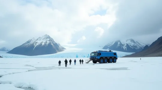
Walking on the Athabasca Glacier: Is the Ice Explorer Tour Worth the $100 CAD?
The $100 Ice Explorer tour is less a tourist ticket and more a fee for engineered safety and managed access to a rapidly vanishing, and inherently dangerous, natural wonder. The cost is justified by the massive operational and safety infrastructure…
Read more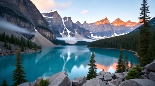
Moraine Lake Access: Why Private Vehicles Are Banned and How to Get There
You can no longer drive your personal or rental car to Moraine Lake road; access is now managed exclusively through shuttles, buses, or cycling. The official Parks Canada shuttle is affordable but sells out almost instantly due to a high-demand,…
Read more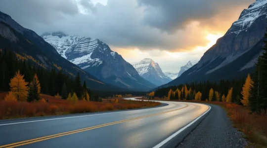
Driving the Icefields Parkway: Safety Tips for Mountain Roads in Shoulder Season
Driving the Icefields Parkway in shoulder season (May/October) demands a shift from a tourist’s mindset to an expeditionary one, where self-reliance is your most critical asset. Road conditions are deceptive, with black ice forming even on sunny days due to…
Read more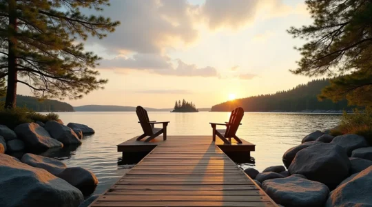
Renting a Muskoka Cottage: The Hidden Costs You Need to Know Before Booking
The idyllic Muskoka cottage experience comes with significant hidden operational costs and unwritten rules that are rarely advertised. High rental prices are just the start; budget for premium groceries, mandatory boat licenses, and potential supply runs for basics like drinking…
Read more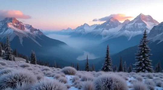
When to Visit the Canadian Rockies: A Local’s Guide to Dodging Crowds and Frostbite
The perfect Rockies trip isn’t about finding a magical, empty month with perfect weather; it’s about understanding the real-world operational trade-offs and choosing the sacrifices you’re willing to make. Peak summer (July/August) offers the best weather and access but comes…
Read more