
The secret to safely experiencing Hopewell Rocks isn’t just checking a tide chart; it’s understanding the predictable physics that govern the Bay of Fundy’s rhythm.
- The tide doesn’t rise evenly. The fastest rise occurs in the 3rd and 4th hours of the cycle, where water can rise over 3 meters in two hours.
- A single park ticket allows re-entry, enabling you to explore at low tide, leave, and return for the high tide spectacle without paying twice.
- Your footwear choice is critical. The ocean floor is thick, suction-creating mud, not sand. Flip-flops are a guaranteed failure.
Recommendation: Use the “Rule of Twelfths” explained in this guide to mentally track the tide’s progress and stay well within the park’s generous safety windows.
The image of the Hopewell Rocks, majestic “flowerpot” formations rising from the ocean floor, is an iconic symbol of Canada’s Maritimes. For many visitors, the dream is to walk on the seabed, gazing up at these giants. But this dream is shadowed by an equally famous fact: the Bay of Fundy has the highest tides on Earth. The thought of being on the ocean floor as 14 meters of water—the height of a four-story building—rushes back in can be paralyzing. This fear leads many to stick to the safety of the lookouts, missing the very experience they came for.
Common advice is to “check the tide schedule,” but this doesn’t quell the anxiety. It doesn’t explain how fast the water moves or how to interpret the six-hour window you have. The real source of confidence isn’t a schedule, but knowledge. The key to exploring Hopewell Rocks without fear is not to outrun the tide, but to understand its relentless, predictable rhythm. It’s about demystifying the power of the bay and learning the simple rules that govern its flow.
This guide acts as your personal safety briefing. We will move beyond simply telling you *when* it’s safe and explain *why*. We’ll break down the science behind the tides, provide a crucial calculation method to estimate water levels, and cover the practical details—from the right footwear to navigating the infamous coastal fog. By understanding the physics of the tide, you can replace apprehension with awe and walk the ocean floor with the confidence of a seasoned local.
This article provides a comprehensive framework for your visit, from the science of the tides to the practicalities of navigating the area. Explore the sections below to build your confidence and plan the perfect, safe adventure at Hopewell Rocks.
Table of Contents: A Guide to Conquering the Fundy Tides
- Why Do the Tides in the Bay of Fundy Rise 14 Meters Twice a Day?
- High Tide vs. Low Tide: Why You Need to Stay for at Least 6 Hours?
- Footwear Failures: Why Flip-Flops Are a Bad Idea on the Ocean Floor?
- Is the Hopewell Rocks Kayak Tour Suitable for Beginners?
- Cape Enrage: How to Enjoy the Views Without Risking the Unstable Cliffs?
- The Rule of Twelfths: How to Calculate Safe Crossing Windows?
- Salt Spray and Frost: How to Keep Your GPS Functional in Coastal Extremes?
- Driving in Fundy Fog: Safety Protocols for Low Visibility Turns
Why Do the Tides in the Bay of Fundy Rise 14 Meters Twice a Day?
The incredible height of the Bay of Fundy’s tides isn’t just a simple case of water rising and falling; it’s the result of a massive geological coincidence known as tidal resonance. Think of the bay as a giant, 270km-long bathtub. Water sloshing from one end to the other has a natural rhythm, or ‘seiche period,’ of about 12 to 13 hours. By a remarkable fluke of nature, this timing perfectly matches the Atlantic Ocean’s tidal cycle, which pushes a new pulse of water into the bay every 12 hours and 25 minutes. This creates a phenomenon similar to pushing a child on a swing: each push is perfectly timed to make the swing go higher and higher.
This “push” is no small nudge. An almost unimaginable volume of water is involved in this daily dance. The funnel shape of the bay, narrowing and shallowing from its mouth to its head, further amplifies this effect. As the water is forced into a tighter space, it has nowhere to go but up. The result is a system of constructive reinforcement where each new tide builds on the energy of the last, culminating in the 14-meter tides seen at Hopewell Rocks. This isn’t just a local event; it’s a vast movement of mass that defines the entire ecosystem.
To grasp the scale, consider that a staggering 160 billion tonnes of seawater surge into and out of the bay with each tidal cycle. That’s more than the combined total flow of all the world’s freshwater rivers. Understanding this immense power and the resonant physics behind it is the first step in respecting the tide’s schedule. It’s not just a guideline; it’s a clockwork mechanism of planetary scale that operates with unwavering precision.
High Tide vs. Low Tide: Why You Need to Stay for at Least 6 Hours?
To truly experience the drama of Hopewell Rocks, you must see it in its two drastically different states: the tranquil, walkable seabed at low tide and the submerged wonderland at high tide. The time between peak high tide and peak low tide is approximately 6 hours and 13 minutes. This means a full cycle from one high tide to the next takes just under 12.5 hours. Therefore, to witness both extremes, a visitor must plan to be in the area for a minimum of six hours. Arriving at peak low tide allows you three hours to explore the ocean floor before the park requires you to return to higher ground. Six hours later, that same spot will be under 14 meters of water.
The visual transformation is staggering, and it’s the very essence of the Hopewell Rocks experience. The image below captures the same rock formation in both its states, highlighting the immense vertical change and the completely different activities possible in each phase.
Fortunately, the park’s logistics are designed to accommodate this long viewing window. As a practical solution for visitors, Hopewell Rocks Provincial Park offers a re-entry policy on its admission tickets. This is a crucial piece of information for planning your day. You can arrive in the morning for low tide, walk the ocean floor, then leave the park for lunch in the nearby village of Alma or visit other local attractions. You can then use the same ticket to return later that afternoon to witness the high tide, perhaps even taking a kayak tour to paddle around the very tops of the formations you walked beside just hours earlier. This policy makes the 6-hour wait not a burden, but an opportunity to explore the wider Fundy region.
Footwear Failures: Why Flip-Flops Are a Bad Idea on the Ocean Floor?
Many first-time visitors picture a pleasant stroll on firm, sandy ground. The reality is quite different. The ocean floor at Hopewell Rocks is not sand; it’s a thick, sticky, clay-like mud known as marine clay. This surface presents two distinct challenges: it’s incredibly slippery, and it creates a powerful suction effect that can literally pull shoes off your feet. This is why footwear choice is not a minor detail—it’s a critical safety and comfort issue. Flip-flops and open-backed sandals are the absolute worst choice; they offer zero grip and are almost guaranteed to be lost to the mud within the first few steps.
So what should you wear? The ideal footwear is something that provides good grip, resists suction, and, importantly, you don’t mind getting completely covered in reddish-brown mud. Old running shoes are often the best choice. They stay on your feet and have decent tread. Water shoes or rain boots are also effective alternatives. Hiking boots, while offering excellent grip, are generally a poor choice because the thick mud gets deeply embedded in their complex treads and is nearly impossible to clean.
The following table provides a clear comparison of common footwear options for tackling the Hopewell Rocks ocean floor.
| Footwear Type | Grip on Mud (1-5) | Suction Resistance (1-5) | Easy to Clean (1-5) | Canadian Availability | Overall Score |
|---|---|---|---|---|---|
| Old Running Shoes | 4 | 5 | 3 | Already own | Best Choice |
| Water Shoes/Aqua Socks | 3 | 4 | 5 | Canadian Tire | Good Alternative |
| Rain Boots | 3 | 5 | 4 | Most households | Acceptable |
| Hiking Boots | 5 | 5 | 1 | Common | Avoid (hard to clean) |
| Flip-Flops/Sandals | 1 | 1 | 5 | Common | Never Use |
No matter what you wear, your shoes will be a mess. The park thoughtfully provides on-site shoe washing stations near the top of the main staircase. Using these immediately after your walk is the best way to deal with the mud before getting back in your car. Being prepared for the cleanup is just as important as the walk itself.
Action Plan: Post-Walk Shoe Cleaning Protocol
- Use the on-site shoe washing stations immediately after climbing back up the stairs from the ocean floor.
- Bring a dedicated plastic or garbage bag to store your muddy shoes for the car ride.
- Pack an extra pair of clean, dry shoes and socks to change into after your walk.
- Consider bringing a small, stiff brush to help remove stubborn clay from the treads and seams of your shoes.
- Allow shoes to dry completely before attempting a final cleaning at home, as dried mud is easier to brush off.
Is the Hopewell Rocks Kayak Tour Suitable for Beginners?
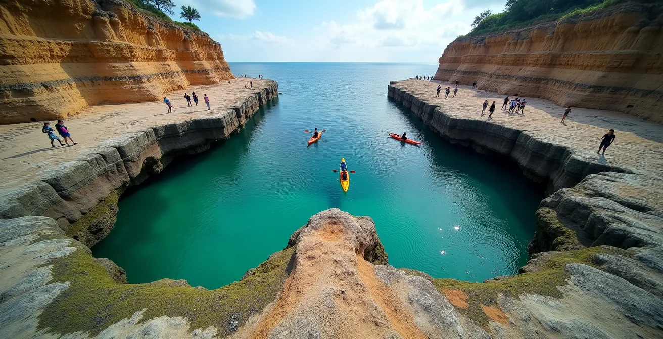
Paddling a sea kayak through the arches of the flowerpot rocks, with the water 40 feet above the ground you could have walked on hours before, is an unforgettable experience. For many, however, the idea of sea kayaking in the bay with the world’s highest tides sounds intimidating, especially for novices. The key question is: are these tours safe for beginners?
The answer is a resounding yes. The primary local operator, Baymount Outdoor Adventures, has structured its tours specifically with beginners in mind. One of the most significant safety factors is the choice of vessel: the tours predominantly use stable tandem (two-person) sea kayaks. These boats are much wider and more stable than solo kayaks, making them very difficult to capsize. Furthermore, you are not sent out alone. All tours are guided by professionals certified by Paddle Canada, ensuring a safe guide-to-paddler ratio and expert oversight at all times.
A Novice Kayaker’s Experience
One first-time paddler shared their experience, encapsulating the concerns of many: “I am a novice kayaker and I absolutely loved this… Like any beginner though, I had some concerns… Will I be able to handle a sea kayak? Will it capsize? Will I be safe? However, all my fears were put to rest by the Baymount Outdoor Adventures team as they thoroughly educated & prepared our group, answering any and all questions.” This highlights the operator’s focus on pre-tour education and reassurance, which is a cornerstone of their safety protocol. The guides are trained in swift rescue procedures, providing a robust safety net for all participants.
The physical demands are also manageable for most fitness levels. According to Baymount Outdoor Adventures, a regular high tide tour lasts between 1.5 to 2 hours, covering approximately 4 km. The pace is leisurely, designed for sightseeing and photography, not for an athletic workout. The tours are conducted at the peak of high tide, when the water is at its “slack” period with minimal current, making the paddling experience calm and controlled. This careful timing avoids the powerful currents that occur when the tide is rushing in or out.
Cape Enrage: How to Enjoy the Views Without Risking the Unstable Cliffs?
While Hopewell Rocks is the main attraction, the nearby Cape Enrage offers a different, wilder perspective on the Bay of Fundy’s power. Here, the focus isn’t on walking the ocean floor, but on the dramatic, eroding cliffs and the historic lighthouse that stands guard over them. The name “Enrage” refers to the turbulent waters where different currents meet, but the risk for visitors today is less from the water and more from the land itself. The jagged sea cliffs are in a constant state of erosion, shaped by the relentless freeze-thaw cycles and tidal action.
The primary safety consideration at Cape Enrage is respecting the instability of the cliffs. These are not solid, granite walls; they are layered sedimentary rock (shale and sandstone) that can and do crumble. The site features jagged sea cliffs that are often more than 50 metres (145 ft) high, and getting too close to an unsupported edge is extremely dangerous. To mitigate this, the site is well-managed with clear safety infrastructure. The most breathtaking views are accessible from designated viewing platforms with sturdy safety railings. It is imperative to stay on marked trails and behind all barriers.
For those seeking adventure, Cape Enrage offers controlled thrills like a zipline and rappelling down a cliff face. These activities are managed by trained professionals with proper safety equipment, providing a safe way to experience the vertical drop. If you wish to access the beach below, you must use the official 30-meter staircase. Never attempt to climb down (or up) the cliffs themselves. As with Hopewell Rocks, timing is everything. Before venturing onto the beach, you must check with Cape Enrage staff for safe walking times based on the tide schedule to avoid being cut off.
The Rule of Twelfths: How to Calculate Safe Crossing Windows?
This is the single most important piece of knowledge for replacing tidal fear with confidence. The “Rule of Twelfths” is a standard maritime guideline used to estimate the speed of the tide. It states that the tide does not rise at a constant speed. Instead, its flow follows a predictable pattern over its six-hour cycle. Understanding this rhythm is the key to realizing why you cannot outrun the tide and why heeding park warnings is not negotiable.
The rule breaks down the six-hour period as follows:
- In the 1st hour, 1/12th of the total tidal range comes in.
- In the 2nd hour, 2/12ths of the range comes in.
- In the 3rd hour, 3/12ths of the range comes in.
- In the 4th hour, 3/12ths of the range comes in.
- In the 5th hour, 2/12ths of the range comes in.
- In the 6th hour, 1/12th of the range comes in.
The critical takeaway is that the tide is at its most powerful and fastest in the middle of its cycle. A full 50% of the total water volume arrives during the third and fourth hours. Let’s apply this to Hopewell Rocks. As a case study on a 12-meter tidal range shows, the water level change is dramatic. In the first hour, the water rises by only 1 meter. But during the third hour alone, it rises by 3 meters (almost 10 feet). In the third and fourth hours combined, the water level increases by a staggering 6 meters—that’s nearly 20 feet, or taller than a moose! This is not a gentle lapping at your ankles; it’s a rapid, relentless vertical rise that can quickly fill channels and cut off exit routes.
Park staff at Hopewell Rocks are experts in this calculation. Their schedules for clearing the ocean floor have a massive safety buffer built in. When they ask you to start heading back, it’s because they know the “3/12ths” phase is approaching. By understanding the Rule of Twelfths, you are no longer just blindly following an order; you are a knowledgeable participant in your own safety.
Salt Spray and Frost: How to Keep Your GPS Functional in Coastal Extremes?
While the tides are the main event, the coastal environment of the Bay of Fundy presents other challenges, particularly for the electronic devices we rely on for navigation and photography. The two biggest culprits are salt spray and cold. The air near the bay is often laden with a fine, salty mist that can work its way into charging ports and onto camera lenses, causing corrosion over time. During the shoulder seasons (May-June and September-October), morning frost or simply the cold air can also dramatically shorten your phone’s battery life.
Proactive protection is key. The simplest and most effective method is to keep your phone or GPS device in a waterproof case or even a heavy-duty Ziploc bag when not in use. This creates a barrier against the corrosive salt spray. To combat battery drain from the cold, keep your devices in an inside pocket close to your body warmth. It’s also essential to carry a fully charged portable power bank as a backup. Never rely solely on your device’s battery for a full day of exploring in this environment.
Perhaps the most critical step happens before you even arrive. Cell service along the Fundy Coastal Drive can be patchy, especially in the more rural areas between attractions. Relying on a live-mapping service is a recipe for getting lost. Before you leave your hotel, use a Wi-Fi connection to download offline maps of the entire region onto your GPS app (like Google Maps or Maps.me). This ensures you have full navigational capability without needing a cell signal. A physical paper map of the province and a printed copy of the tide tables are also invaluable, low-tech backups that never run out of battery.
Checklist: Pre-Visit GPS and Electronics Prep
- Download offline maps for the entire Fundy Coastal Drive region (Moncton to St. Martins) before arriving.
- Fully charge all devices (phone, camera, GPS) and portable power banks the night before your visit.
- Pack all sensitive electronics in waterproof cases or, at a minimum, heavy-duty resealable plastic bags.
- During cooler months, plan to keep your phone in an inside jacket pocket to preserve battery life.
- After visiting the beach, check and clean charging ports with a puff of air to remove any salt or sand residue.
- Pack the ultimate backups: a printed tide table for the day and a physical road map of New Brunswick.
Key takeaways
- The Bay of Fundy’s 14-meter tides are caused by tidal resonance, where the bay’s natural rhythm matches the ocean’s tidal pulse.
- The tide rises fastest in the 3rd and 4th hours of its 6-hour cycle (the “Rule of Twelfths”), making it impossible to outrun.
- A single park ticket allows re-entry, so you can witness both low and high tide in one day by leaving and returning.
Driving in Fundy Fog: Safety Protocols for Low Visibility Turns
The same massive body of water that creates the world’s highest tides also generates a frequent and challenging weather phenomenon: the infamous “Fundy Fog.” This is not a light mist but a thick, disorienting blanket that can roll in from the water with surprising speed, dramatically reducing visibility on coastal roads. This can create driving conditions as hazardous as any mountain pass. As Environment Canada notes, this is a frequent local phenomenon that can roll inland, creating severely limited visibility. Therefore, checking the weather forecast before you drive is only half the battle; you must also check the Marine Forecast for specific fog advisories.
When you encounter a fog bank, the most important action is to immediately reduce your speed. Driving at 30-50 km/h may feel slow, but it’s essential for having enough time to react. Your first instinct might be to turn on your high beams, but this is counterproductive. High beams reflect off the water droplets in the fog, creating a wall of white glare that further reduces your own visibility. Instead, use your low beams and, if your vehicle has them, your fog lights, which are aimed lower to illuminate the road surface beneath the fog.
To maintain your position on the road, it’s safer to follow the solid white line on the right-hand edge of the road rather than the centre line. This prevents you from drifting into the oncoming lane. Keeping a window slightly cracked can also help you hear other vehicles before you see them. Finally, be hyper-aware of wildlife. Moose and deer are common in New Brunswick and are much harder to spot in foggy conditions. If visibility becomes almost zero, the safest option is to find a designated pull-off area and wait for conditions to improve. Being patient is a critical part of staying safe on the beautiful but sometimes treacherous Fundy coast.
By now, you are equipped with the knowledge to transform fear into respect and apprehension into adventure. You understand the immense physics of the bay, the practical rhythm of the tidal cycle, and the ground-level details that ensure a safe and memorable trip. You are ready to explore. For a truly confident visit, start by applying these principles to the official tide schedule for your chosen date.