
Driving the Icefields Parkway in shoulder season (May/October) demands a shift from a tourist’s mindset to an expeditionary one, where self-reliance is your most critical asset.
- Road conditions are deceptive, with black ice forming even on sunny days due to the melt-freeze cycle.
- Services are non-existent; you are your own gas station, mechanic, and first responder in a 232-kilometre resource desert.
Recommendation: Treat this drive not as a simple A-to-B trip, but as a calculated venture into a remote environment. Your preparation directly determines your safety.
The Icefields Parkway is often sold as one of the world’s most beautiful drives, and it is. But if you’re planning this trip in the shoulder season months of May, early June, or October, what the brochures don’t tell you is that Highway 93 becomes a different beast entirely. You’ve likely heard the standard advice: check the weather, watch for animals. That’s fine for a summer cruise, but it’s dangerously inadequate when you’re facing unpredictable mountain conditions in a rental car.
Most guides focus on the sights, not the survival. They’ll tell you about the beauty of a half-frozen lake but won’t explain the mechanics of the melt-freeze cycle that creates invisible black ice on the road next to it. They’ll mention the lack of cell service as a fun fact, not as a critical operational detail that could leave you stranded and invisible for hours. This isn’t about fear-mongering; it’s about respect for the environment you’re entering. Your beautiful road trip can turn into a serious situation if you’re not prepared for the reality of the Rockies outside of peak season.
So, let’s set aside the tourist checklist for a moment. The real key to a successful and safe journey on the Parkway in spring or fall isn’t about seeing everything; it’s about anticipating everything. It’s a mindset of total self-reliance. This guide is built on that principle. We’ll move beyond the generic tips and into the practical, operational knowledge you need to handle this drive with the confidence of a local, covering everything from fuel strategy and icy road dynamics to what to do when you’re truly offline and on your own.
text
This article will provide a structured approach to navigating the unique challenges of a shoulder season drive. The following sections break down the essential preparations and on-the-road decisions you’ll need to make.
Summary: A Strategic Guide to the Icefields Parkway in Shoulder Season
- Why You Must Fill Up Your Tank Before Entering the Icefields Parkway?
- Discovery Pass vs. Day Pass: Which Is Cheaper for a 4-Day Rockies Trip?
- What to Do If You Encounter a Bighorn Sheep Herd on the Highway?
- Staying on the Parkway: Are the Hostels and Lodges Worth the Premium?
- Surviving Without Cell Service: How to Navigate Highway 93 Offline?
- How to Drive the Icefields Parkway safely When Roads Are Icy?
- The Skywalk Glass Floor: Thrill or Overpriced Tourist Trap?
- Moraine Lake Access: Why Private Vehicles Are Banned and How to Get There?
Why You Must Fill Up Your Tank Before Entering the Icefields Parkway?
Thinking a half-tank is “good enough” is the first and most common mistake a driver can make. You need to understand that the Icefields Parkway is a 232-kilometre resource desert. The last reliable gas stations are in Jasper or Lake Louise. Between them, there is only one seasonal station at Saskatchewan River Crossing, which is often closed in May and October. Running out of fuel here isn’t an inconvenience; it’s a genuine emergency. With no cell service, you can’t call for help. You’re left waiting for a Parks Canada vehicle or a kind stranger, which could take hours.
Furthermore, your car’s fuel economy on flat, warm highways has no bearing on its performance here. Mountain driving, with its constant elevation changes, naturally uses more fuel. Cold weather, which is common during shoulder season mornings and evenings, compounds this problem significantly. According to official tests, conventional vehicles can experience a fuel economy drop of 15% to 33% in cold conditions. That theoretical 400 km range on your rental car’s dashboard can quickly become less than 300 km in reality.
Treat your fuel tank as a primary piece of safety equipment. The rule is simple and non-negotiable: start with a full tank. This isn’t just about making it to the other end; it’s about having the freedom to stop, to backtrack if a section of road is bad, or to simply keep the engine running for heat if you’re stopped for an extended period due to an accident or wildlife. A full tank is your buffer against the unpredictable.
Your Fuel Planning Checklist
- Fill up at last-chance stations: Ensure a full tank at Jasper townsite or Lake Louise village before entering the parkway.
- Calculate your vehicle’s real-world range: Know your tank capacity and typical L/100km, then add a significant buffer for mountain driving.
- Factor in cold weather: Add a 20-30% buffer to your normal fuel consumption calculation, especially for morning drives.
- Check Saskatchewan River Crossing status: Before you leave, verify if the only fuel stop on the 232km route is open, but do not rely on it.
- Know your point of no return: At the halfway mark (116km), ensure you have well over half a tank left to complete the journey safely.
Discovery Pass vs. Day Pass: Which Is Cheaper for a 4-Day Rockies Trip?
Before you even get to the Parkway, you’ll need a Parks Canada pass, which you must display in your vehicle at all times. The choice between a daily pass and an annual Discovery Pass can be confusing, but for a multi-day trip, the math is usually straightforward. A daily pass is purchased per person or per vehicle, for each day you are in the national parks (Banff, Jasper, Yoho, etc.). For a solo traveller, this can seem cheaper initially, but the costs add up quickly for couples or groups.
Let’s break down the decision for your specific 4-day trip. A daily pass for an adult costs money per day, while a family/group pass covers everyone in the vehicle. The annual Discovery Pass, however, is valid for a full 12 months and covers entry to over 80 Parks Canada sites across the country. For anyone travelling with even one other person for 4 or more days, the annual group pass often becomes the break-even point or the cheaper option. This is especially true if you plan to visit any other Canadian national park within the year.
The value of the Discovery Pass extends beyond just the entry fee. During busier periods, even in the shoulder season, pass holders can sometimes use dedicated express lanes at park entrance gates, saving valuable daylight hours. For a 4-day Rockies trip, the Family/Group Discovery Pass is almost always the most economical and convenient choice for any party of two or more people. It simplifies your entry and provides better overall value.
This comparative analysis breaks down the cost implications for different traveller types on a typical 4-day trip, as detailed in an analysis of Parks Canada fees.
| Pass Type | Cost (CAD) | Coverage | Best For |
|---|---|---|---|
| Adult Day Pass (4 days) | $44.00 | One adult, single park | Solo travelers, short trips |
| Family/Group Day Pass (4 days) | $88.00 | Up to 7 people in one vehicle | Couples, families (3+ days) |
| Adult Discovery Pass (Annual) | $75.25 | One adult, 80+ parks | 7+ day trips or multiple visits |
| Family/Group Discovery Pass (Annual) | $151.25 | Up to 7 people in one vehicle, 80+ parks | Groups of 2+ for 4+ days |
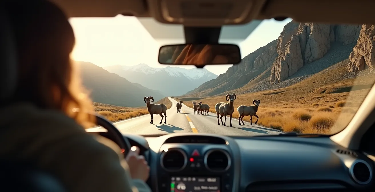
What to Do If You Encounter a Bighorn Sheep Herd on the Highway?
It’s not a matter of *if* you’ll see wildlife, but *when*. And on the Parkway, that often means animals directly on the asphalt. Bighorn sheep, in particular, are notorious for congregating on the road to lick salt and minerals. Encountering a herd blocking your path can be intimidating, and the wrong reaction can be dangerous for both you and the animals. The cardinal rule is patience and predictability. Your goal is to be a boring, slow-moving object that they will eventually ignore and move away from.
Never honk your horn. This is a common and dangerous mistake. A loud noise will panic the herd, causing them to scatter unpredictably, potentially into the path of oncoming traffic or causing them to damage your vehicle. Instead, slow down to a crawl—20 km/h or less—long before you reach them. Give them a wide berth if possible. Often, they will part and let you pass slowly. If they don’t, you stop and wait. This is their home; you are the visitor. Remember that “bear jams” are also common. The rule here is to stay in your vehicle. Stopping for a prolonged period habituates animals to humans and vehicles, which is incredibly dangerous for them in the long run.
The Canadian government takes this very seriously. Under the Canada National Parks Act, disturbing wildlife can lead to fines of up to $25,000. This includes feeding them, approaching them for a photo, or harassing them with your vehicle. Use your car as a “blind” or a shelter, use a zoom lens for photos, and maintain a safe distance—at least 30 meters for elk and sheep, and 100 meters for predators like bears, cougars, or wolves.
As this perspective shows, the correct approach is to maintain a significant distance and let the animals dictate the timeline. Your schedule is secondary to their safety. Known hotspots for these encounters include the “Goats and Glaciers” viewpoint area and the sharp bends south of the Weeping Wall, so be extra vigilant in these zones.
Staying on the Parkway: Are the Hostels and Lodges Worth the Premium?
Deciding where to sleep is a major strategic choice. Driving back to Jasper or Banff at night is not a viable option. The risk of hitting wildlife or black ice in the dark is far too high. This leaves you with two choices: stay at one of the few lodges on the Parkway itself, or ensure your day’s drive ends safely in a town before dusk. In the shoulder season, this decision is often made for you, as most on-parkway accommodations are closed. Sunwapta Falls and Glacier View lodges, for example, typically close by mid-October and don’t reopen until May. The Crossing Resort may have a slightly longer season, but you must verify its operational dates.
This means for much of May and October, you must be completely self-sufficient. If you are lucky enough to find an open lodge, you will pay a premium. Is it worth it? From a safety and experience perspective, absolutely. Staying on the Parkway eliminates all night driving. It gives you immediate access to sunrise and sunset light for photography, and the chance to experience the profound silence and dark skies of the valley without any light pollution. You can be at the foot of a glacier at first light while others are still an hour’s drive away.
The trade-off is cost and amenities. You’ll pay significantly more than you would in town, and you must bring your own food and supplies, as most, if not all, restaurants and shops will be closed. The decision comes down to a simple risk-reward calculation, where safety is the most heavily weighted factor.
| Factor | Stay on Parkway | Drive to Town |
|---|---|---|
| Nightly Cost | $220-450 CAD | $120-250 CAD |
| Dark Sky Access | Immediate, no light pollution | Requires night driving |
| Morning Photography | First light at glaciers/lakes | 60-90 min drive required |
| Safety Risk | Zero night driving on icy roads | High risk: wildlife, black ice, limited visibility |
| Food Options | Must bring supplies (restaurants closed) | Full town amenities available |
Surviving Without Cell Service: How to Navigate Highway 93 Offline?
Let’s be perfectly clear: there is no cell service on the vast majority of the Icefields Parkway. Not weak service, not intermittent service. Zero. Don’t assume you can “find a high spot” to get a signal; the valley’s geography makes it impossible. This is the definition of being offline. Relying on your phone’s live mapping is not an option. Your preparation for this digital blackout is a cornerstone of your self-reliance strategy.
Your primary tool should be offline maps. Before you leave WiFi, download the entire Jasper-to-Banff corridor on an application like Google Maps. This will allow your phone’s GPS chip to function, providing turn-by-turn directions and locating you on the map without needing a data connection. For more detail, especially for trailheads and points of interest, an app like Maps.me is superior. It often shows unmarked viewpoints and trail contours that Google misses.
However, technology can fail. Batteries die, apps crash, phones get dropped. That’s why the “Holy Trinity” of offline navigation is essential: 1. A primary GPS app with the map downloaded (Google Maps). 2. A secondary, more detailed app for points of interest (Maps.me). 3. A physical, waterproof map, like those made by Gem Trek. A paper map never needs charging and gives you the “big picture” at a glance, showing avalanche zones and wildlife corridors that apps don’t. It’s your ultimate backup.
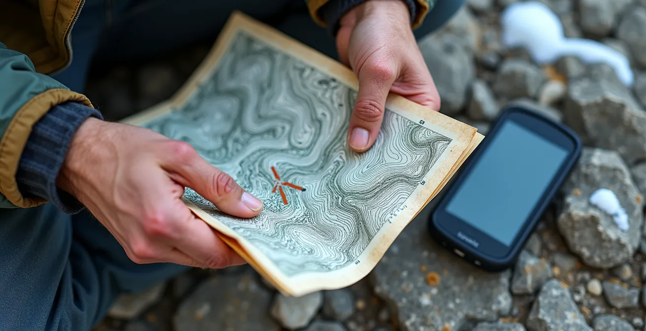
For those venturing into any backcountry hikes, even short ones, a satellite communicator like a Garmin inReach or ZOLEO is a critical piece of safety gear. These devices operate via satellite and can send an SOS signal to an emergency coordination center, which can then dispatch Parks Canada Visitor Safety teams. This is your only lifeline in a serious emergency. Plan for complete disconnection, and you will navigate with confidence.
How to Drive the Icefields Parkway safely When Roads Are Icy?
The most significant and underestimated danger of the shoulder season is ice. You can have a beautiful, sunny day, but the road surface can still be treacherous. This is due to the melt-freeze cycle. During the day, the sun melts snow on the mountainsides, and the water runs across the road. As soon as that section of road enters shadow or the sun sets, that water instantly freezes into a nearly invisible layer of black ice. This is most common on bridges, in shaded corners, and near waterfalls, especially before sunrise and after 4 PM.
Your first line of defense is your tires. While Alberta does not legally mandate winter tires on the Parkway, your rental must have them. British Columbia, where many visitors start their journey, *does* require M+S (Mud and Snow) or winter-rated (three-peak mountain snowflake symbol) tires on most highways from October 1 to April 30. Standard “all-season” tires are dangerously inadequate. They harden in the cold and offer very little grip on ice. When you book your rental from Calgary (YYC) or Vancouver (YVR), you must explicitly request and confirm that the vehicle is equipped with proper winter-rated tires.
If you hit a patch of black ice, your reaction must be calm and precise. Do not slam on the brakes. This will lock your wheels and guarantee a skid. Immediately ease your foot off the accelerator and keep the steering wheel pointed straight in the direction you want to go. The most dangerous temperatures are actually between -4°C and +4°C, when these melt-freeze cycles are most active. “False spring” in April/May brings morning ice from overnight refreezing, while “first winter” in October/November can catch drivers unprepared with sudden blizzards and the first black ice of the season.
Drive proactively. Reduce your speed significantly in shaded areas or on bridges. Watch for a glossy sheen on the road ahead. If the cars in front of you are suddenly slowing for no reason, assume it’s ice. Your caution is the best tool you have to prevent an accident.
Key Takeaways
- Self-reliance is mandatory: Assume no fuel, no food, no cell service, and no immediate help is available.
- Shoulder season conditions are deceptive: A sunny day can still mean black ice in shaded corners due to the melt-freeze cycle.
- Preparation is proactive, not reactive: Your safety is determined by the choices you make before you even start the engine (tires, fuel, offline maps).
The Skywalk Glass Floor: Thrill or Overpriced Tourist Trap?
The Columbia Icefield Skywalk is a major attraction: a glass-floored platform suspended 280 metres over the Sunwapta Valley. For some, it’s a thrilling, must-do experience. For a pragmatic driver on a budget, it warrants a closer look. The price tag is significant (often $35+ per person), and its value depends entirely on your travel style. It is also closed from November to April, so checking its operating dates in the shoulder season is your first step.
For a family with kids seeking a memorable thrill, the Skywalk can be worth the price, especially when bundled with a tour onto the glacier itself. The unique perspective is undeniable, and the engineering is impressive. However, for a nature purist or a budget backpacker, the experience can feel commercial and disconnected from the wild landscape it overlooks. You are paying a premium for a view that, in many ways, can be rivalled by free alternatives nearby.
If the price gives you pause, consider these expert-approved, no-cost options. The switchback viewpoint on the highway just north of the Columbia Icefield Centre offers a staggering, panoramic view of the Athabasca Glacier and the surrounding peaks for free. For a more intimate experience, the accessible Forefield Trail at the base of the glacier lets you get close to the ice (from a safe distance) and feel its immense scale without a ticket. Photography enthusiasts might find that the best, most natural compositions are found on the Wilcox Ridge Trail, which provides an elevated viewpoint of the entire icefield that many consider superior to the Skywalk’s view.
Ultimately, the Skywalk is a well-marketed attraction. If the idea of the glass floor excites you and it’s in your budget, it can be a fun stop. But if you’re seeking awe on a budget or a more authentic connection with the landscape, your money and time are better invested in the trails and viewpoints that dot the rest of the Parkway.
Moraine Lake Access: Why Private Vehicles Are Banned and How to Get There?
Moraine Lake, with its iconic valley of the ten peaks, is a primary destination for many visitors. However, you must understand this: private vehicles are banned from the Moraine Lake road year-round. The road itself is also closed to all traffic for most of the year due to extreme avalanche risk. Critical information often missed by visitors is that the road is typically closed for 7-8 months annually, usually opening only in early June and closing again after the Canadian Thanksgiving weekend in October.
This means for a trip in May, access is impossible. For a trip in early October, you are racing against a hard deadline that can be moved up by an early snowfall. When the road is open, access is strictly limited to Parks Canada shuttles, Roam Transit, and licensed commercial transport operators. Shuttle spots are released online at 8 AM Mountain Time, exactly two days prior to the travel date, and they sell out within minutes. Planning to “just show up” will result in disappointment.
Given these tight restrictions, it’s wiser to focus on the spectacular lakes that are accessible during your shoulder season trip. This manages expectations and prevents your itinerary from revolving around an inaccessible location. Consider these incredible, accessible alternatives:
- Lake Louise: The main lake is accessible year-round. In May or October, you can experience a sunrise here with a fraction of the summer crowds.
- Peyto Lake: The viewpoint is usually accessible once the Parkway is in good condition (typically late May/early June). Its brilliant turquoise colour is visible even when partially frozen.
- Bow Lake: Located directly on the Icefields Parkway, it’s accessible whenever the road is open and offers stunning views of the Bow Glacier and Crowfoot Mountain.
- Two Jack Lake: Near the town of Banff, its lower elevation means the ice melts earlier and it has a longer accessible season for beautiful photos of Mount Rundle.
Don’t let your trip be defined by a single, difficult-to-access lake. The Rockies are filled with hundreds of equally beautiful locations that are far more rewarding to visit during the quiet, dramatic shoulder season.
Now that you’re equipped with this operational mindset, your drive on the Icefields Parkway can be what it’s meant to be: a safe, awe-inspiring journey through one of the planet’s most incredible landscapes. Plan for self-reliance, respect the conditions, and you’ll have an unforgettable experience.