In summary:
- Fog is a predictable feature, especially in early summer on the Atlantic side; it doesn’t have to ruin your trip.
- Proactive safety, not passive fear, is key. This means reducing speed by a mandatory 30% and using offline maps.
- The greatest danger isn’t the cliffs, but wildlife like moose, which are nearly invisible in mist.
- Embracing the fog can lead to unique atmospheric photos and a more memorable sensory experience.
The thought of it can tie a driver’s stomach in knots: you, a rental car, and the legendary Cabot Trail, with its winding cliffside roads, suddenly swallowed by a thick blanket of Atlantic fog. Your knuckles turn white on the steering wheel. Every blind curve feels like a gamble. Is the view gone? Is it even safe to continue? This fear is valid and it’s the single biggest concern for many visitors planning their dream trip to Cape Breton Island.
Most advice you’ll find is frustratingly generic: “drive slow,” “be careful.” While true, these platitudes do little to empower a nervous driver. They don’t explain the specific physics of fog on the coast, the critical difference between the trail’s eastern and western shores, or the non-negotiable protocols for avoiding the single most significant danger: wildlife in the mist. Fear thrives in the unknown, but the fog of the Cabot Trail is not an unpredictable monster; it’s a known quantity with patterns and rules.
This guide offers a different approach. We will move beyond vague warnings to provide a strategic protocol for mastering the drive. Instead of just fearing the fog, you will learn to understand its behaviour, leverage the right technology to navigate through it, and adopt specific techniques to manage the real risks. We will transform your anxiety into preparedness, showing you not only how to drive the trail safely in low visibility, but also how to find unexpected beauty and adventure within the mist itself.
This comprehensive guide breaks down everything you need to know to confidently and safely navigate one of Canada’s most scenic drives, no matter the weather. Follow along as we cover the science of coastal fog, essential safety protocols, and even how to appreciate the journey when the panoramic views disappear.
Summary: A Driver’s Strategic Handbook to the Cabot Trail in Fog
- June Gloom: Why Early Summer Is the Foggiest Time on the Atlantic Coast?
- Atmospheric Photography: How to Shoot Moody Landscapes in the Mist?
- GPS Reliance: Why You Need Offline Maps When the Fog Hides Signs?
- Moose in the Mist: Why You Must Reduce Speed by 30% in Foggy Zones?
- Peggy’s Cove in the Fog: Is It Still Worth the Drive from Halifax?
- What to Do If You Encounter a Bighorn Sheep Herd on the Highway?
- Driving Through a Prairie Supercell: What to Do If You See a Tornado?
- Sleeping in a Lighthouse: Which Historic Keepers’ Cottages Are Open to Tourists?
June Gloom: Why Early Summer Is the Foggiest Time on the Atlantic Coast?
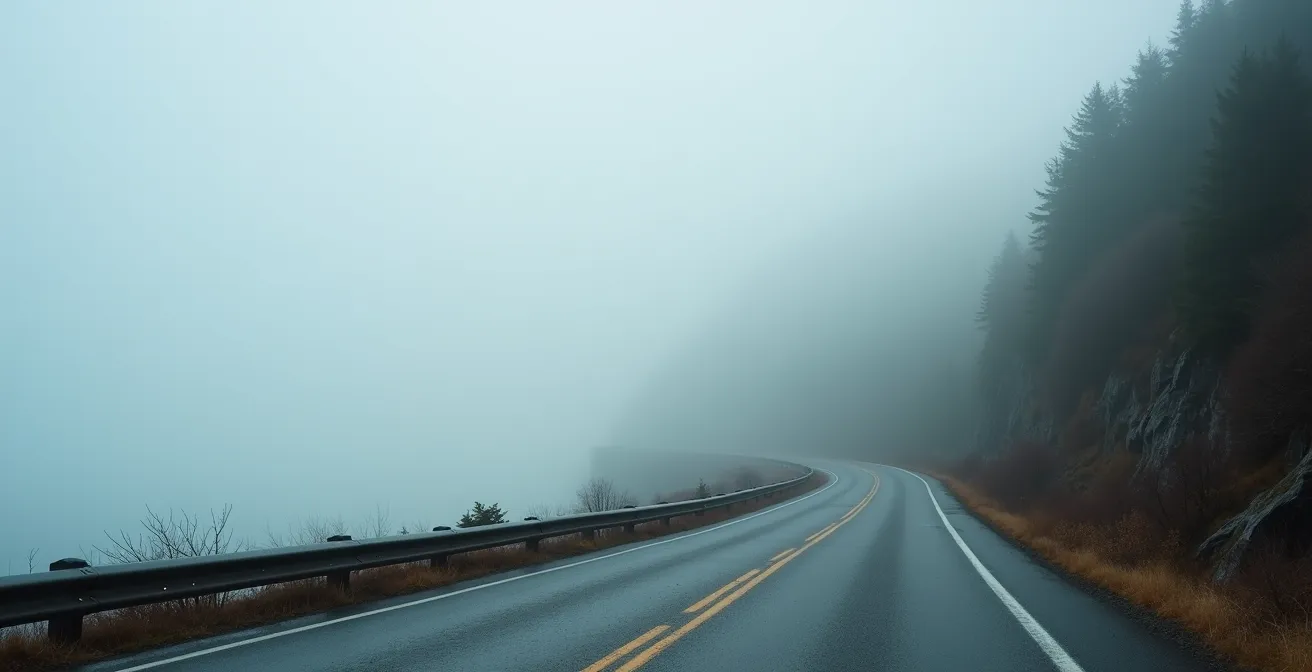
That iconic Cabot Trail fog isn’t random; it’s a predictable phenomenon, especially in early summer. The science is simple: warm, moist air from the south glides over the still-cold Atlantic waters of the Nova Scotia coast. This temperature clash cools the air to its dew point, creating dense advection fog. While it can occur anytime, local experience confirms it’s most common in June and July. According to local travel forums, June visitors frequently report early morning fog that typically dissipates once the sun gains strength.
However, the most crucial piece of local knowledge is that not all parts of the Cabot Trail are equal. Your direction of travel matters immensely. The eastern side of Cape Breton, facing the open Atlantic (including areas like Ingonish), is far more susceptible to these thick fog banks. In contrast, the western side, which faces the warmer Gulf of St. Lawrence (including Chéticamp), often remains clear. This isn’t just theory; it’s a consistent pattern that can make or break your day.
Case Study: The Tale of Two Coasts
Travellers consistently report significant fog variations between the Atlantic-facing Ingonish area and the Gulf-facing Chéticamp side. One visitor noted the Chéticamp side experienced ‘very little fog, lots of blue sky,’ while just a 30-minute drive away, the eastern Atlantic coast was completely shrouded in morning fog. This highlights a key strategy: if you wake up to dense fog in Ingonish, don’t cancel your day. Driving west towards the mountains often means breaking through into bright sunshine.
This geographic variance is your strategic advantage. Driving the trail in a clockwise direction (starting up the west coast from Chéticamp) often means you’ll have clear skies for the dramatic highland climbs in the morning and descend into the potentially foggy eastern side later in the day, when the sun has had a chance to burn it off. This simple choice can dramatically reduce your chances of driving the most challenging sections in low visibility.
Atmospheric Photography: How to Shoot Moody Landscapes in the Mist?
When a wall of fog rolls in, it’s easy to feel disappointed that the sweeping panoramic vistas have vanished. However, for a photographer, this is not a loss but an opportunity. Fog simplifies a busy landscape, isolates subjects, and creates a powerful, moody atmosphere that a clear blue sky can never replicate. The key is to shift your focus from the grand to the intimate and to do so with an unwavering commitment to safety.
First, never treat the side of the road as your studio. The Cabot Trail’s shoulders are narrow and stopping on them in low visibility is extremely dangerous. Your primary rule is to only park at designated lookoffs or pull-offs. Parks Canada has strategically placed these spots, many marked with their iconic red chairs, precisely because they offer safe vantage points. The first few lookoffs past Chéticamp heading up French Mountain are particularly famous for offering dramatic views of fog-wrapped cliffs even in poor weather.
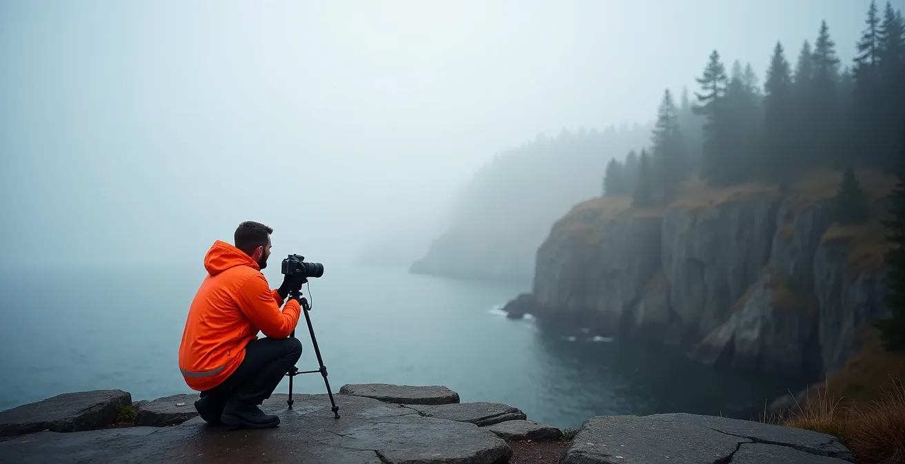
As you can see, the right gear and a safe location are paramount. A tripod is essential in the low light of a foggy day to avoid blurry shots. Focus on compositions with strong foreground elements—a gnarled tree, a section of guardrail, or the edge of the cliff—to create a sense of depth and scale. The fog will act as a natural softbox, diffusing the light beautifully and making colours appear rich and saturated. Look for layers in the mist, where parts of the landscape are revealed and concealed, adding mystery to your shots. The Skyline Trail boardwalk is another excellent, safe option, providing an elevated platform that can sometimes put you above the fog for truly magical images.
GPS Reliance: Why You Need Offline Maps When the Fog Hides Signs?
In thick fog, your world shrinks to the few metres of pavement visible in front of your car. Road signs for lookoffs, trailheads, and even crucial turns can become invisible until you’re right upon them—or have already passed them. In this scenario, your GPS becomes your lifeline. However, relying on a live-streaming app like Google Maps or Waze is a critical mistake on the Cabot Trail. There are significant “digital dead zones” with no cellular service, leaving you completely blind if you haven’t prepared.
The most notorious dead zones are within the Cape Breton Highlands National Park, particularly on the mountainous sections between French Mountain and MacKenzie Mountain—the very areas with the most hairpin turns and dramatic elevation changes. As noted by experienced hikers in AllTrails Cabot Trail hiking reports, this lack of coverage is not a possibility, but a certainty.
The Cape Breton Highlands National Park has specific dead zones with no cellular coverage, particularly between French Mountain and MacKenzie Mountain sections.
– AllTrails Community Reviews, AllTrails Cabot Trail hiking reports
The only solution is to download offline maps *before* you lose service. Several apps are designed for this purpose, but they offer different levels of detail. Your choice depends on your planned activities. For driving, an app with turn-by-turn voice navigation is superior, as it allows you to keep your eyes on the road. For hikers, detailed topographic maps and trail markers are more important.
This table compares popular options for navigating the Cabot Trail’s dead zones. Your primary concern should be robust offline functionality and detailed road network data.
| App Feature | Gaia GPS | AllTrails | Parks Canada App |
|---|---|---|---|
| Offline Maps | Full topographic | Trail-focused | Park boundaries only |
| Voice Navigation | Turn-by-turn available | Limited to trails | Not available |
| Breadcrumb Tracking | Yes, with export | Yes, basic | No |
| Coverage Quality | Excellent in highlands | Good on marked trails | Basic park info |
Ultimately, a dedicated offline map is a non-negotiable piece of safety equipment. It provides the situational awareness you need when visibility is near zero, alerting you to upcoming sharp turns and allowing you to anticipate the road ahead long before you can see it.
Moose in the Mist: Why You Must Reduce Speed by 30% in Foggy Zones?
Let’s be perfectly clear: the most significant danger when driving the Cabot Trail in fog is not driving off a cliff. It is colliding with a moose. These massive animals, which can weigh over 500 kilograms, are notoriously difficult to see. Their dark, non-reflective coats absorb headlight beams, and in the disorienting whiteout of a fog bank, they can appear with absolutely no warning. Your normal reaction time is insufficient, which is why a drastic speed reduction is not a suggestion—it’s a rule of physics.
Standard safety guidelines indicate that fog limits visibility to less than 1 km, but on the Cabot Trail, it can easily drop to less than 50 metres. At 90 km/h, you are travelling 25 metres per second. Your “moose reaction window”—the time you have to see, process, and brake for an obstacle—is a mere two seconds, which is not enough to stop. Reducing your speed by 30% to around 60 km/h extends that window, giving you a fighting chance to avoid a catastrophic impact. Never use your high beams; the light will reflect off the water droplets in the fog, creating a wall of glare and reducing your visibility even further.
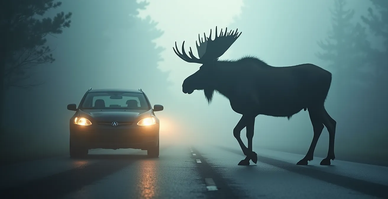
This visual demonstrates the terrifying reality of a moose collision. The animal’s long legs mean the initial impact is often at windshield level, making these accidents incredibly dangerous for vehicle occupants. Because moose are most active at dawn and dusk—the same times when fog is often thickest—the risk is compounded. You must be hyper-vigilant, actively scanning the edges of the road for any sign of movement or the glint of their eyes.
Action plan: Moose encounter protocol in fog
- Reduce Speed Immediately: Upon entering any foggy zone, especially at dawn or dusk, reduce your speed by at least 30%.
- Scan for Eye Reflection: Watch for the faint reflection of eyes in the mist; they may be visible before the animal’s dark body.
- Use Low Beams Only: Never use high beams in fog, as the glare will severely reduce your own visibility and won’t illuminate a moose’s dark coat.
- Stop for One, Expect Two: If you spot a moose, stop completely. They often travel in pairs or with a calf. Do not honk or try to drive around it.
- Report Collisions: If a collision occurs, report it immediately to Parks Canada wardens using the designated emergency numbers to ensure the safety of other drivers.
Peggy’s Cove in the Fog: Is It Still Worth the Drive from Halifax?
The quintessential postcard image of Peggy’s Cove is its iconic lighthouse standing sentinel over sun-drenched granite rocks against a backdrop of the sparkling Atlantic. So, if you wake up in Halifax to a thick, damp fog, is the hour-long drive still worth it? For many, the answer is a resounding yes, provided you adjust your expectations from the visual to the experiential.
What you lose in panoramic vistas, you gain in atmosphere. Fog transforms Peggy’s Cove into an entirely different, almost mystical place. The visual noise disappears, replaced by a profound sensory experience. You’ll hear the mournful, rhythmic blast of the foghorn, a sound that is both haunting and deeply maritime. The crash of unseen waves on the rocks becomes more powerful, and the salty spray on your face feels more immediate. It’s an experience that can be far more memorable and emotionally resonant than a standard sunny day.
Case Study: The Atmospheric Compensation of a Foggy Visit
Photographers and visitors frequently report that while fog obscures the classic views at Peggy’s Cove, it creates a uniquely atmospheric journey. The experience is defined by the mournful foghorn, the sound of invisible waves crashing, and an ethereal, otherworldly quality. Many find this sensory immersion—feeling the salt spray, hearing the muffled sounds, and soaking in the mysterious atmosphere—to be a more powerful and memorable experience than a clear-day visit, proving that “bad” weather can provide its own rewards.
However, this atmospheric beauty comes with a stern warning: the danger at Peggy’s Cove is amplified exponentially in the fog. The infamous black rocks are treacherous when wet and slippery. Rogue waves, which have tragically claimed lives here, are impossible to see coming in the mist. The warning signs posted throughout the area are not suggestions; they are deadly serious. Stay well back from the water’s edge and remain on the light-coloured, dry granite at all times. The fog creates a sense of intimacy, but it also breeds a false sense of security. The raw power of the ocean is still there, just hidden from view.
What to Do If You Encounter a Bighorn Sheep Herd on the Highway?
While your immediate concern on the Cabot Trail is moose, the principles of managing wildlife encounters on the road are universal across Canada. A prime example comes from the Rocky Mountains, where drivers frequently encounter herds of Bighorn Sheep directly on the highway. Though geographically distant, the protocol for this situation offers valuable lessons in patience and passive safety that are directly applicable to any large animal encounter, including in Nova Scotia.
The most important rule is to stop immediately and resist the urge to honk or slowly push through the herd. Unlike a solitary moose that might bolt, a herd of sheep operates with a group mentality. Honking can cause panic, scattering the animals unpredictably into both lanes of traffic and increasing the risk of collision. Your safest action is inaction. Turn on your hazard lights to warn other drivers, and simply wait. The animals are often on the road for a specific reason—in the Rockies, they are typically licking road salt for essential minerals—and they will move on when they are ready.
Patience is your greatest tool. You must maintain a complete stop until every single animal has cleared the roadway. Often, a dominant ram will be the last to move, ensuring the rest of the herd is safely across. Once the path is completely clear, proceed at a crawl (under 5 km/h) until you are well past the area. Rushing away creates a risk of hitting a straggler you didn’t see. Reporting persistent herds to the local Parks Canada wardens is also a crucial step, as it helps wildlife management teams monitor animal behaviour and ensure public safety.
Driving Through a Prairie Supercell: What to Do If You See a Tornado?
Driving in fog presents a challenge of limited visibility, but other parts of Canada face weather threats that are orders of magnitude more violent. Consider the prairie supercell, a massive, rotating thunderstorm capable of producing giant hail, flash floods, and tornadoes. While you won’t face a tornado on the Cabot Trail, understanding the safety protocols for such an extreme event reinforces a critical lesson for any driver: when faced with severe weather, you must have a plan and rely on official sources, not just hope.
If you are driving on the prairies and spot a tornado, your actions are dictated by its distance and movement. If it is far away, the safest strategy is to drive at a right angle away from its path. However, the most critical piece of advice is what *not* to do: NEVER seek shelter under a highway overpass. It’s a common and deadly mistake. The overpass acts like a wind tunnel (a Venturi effect), dramatically increasing wind speed and concentrating flying debris. You are far more exposed there than in the open.
If escape is impossible, your only option is to abandon your vehicle and get as low as possible. Lie flat in the lowest point you can find, like a ditch, covering your head with your hands. This is a last resort, as you must also be aware of the risk of flash floods in the very same ditches. The key takeaway for any severe weather situation, from fog to tornadoes, is to be proactive. According to Environment Canada’s weather safety guidelines, you should always monitor official weather alerts rather than generic apps, as they provide the most accurate and timely warnings for life-threatening conditions. This preparedness is the foundation of safe travel in any unpredictable environment.
Key takeaways
- Fog on the Cabot Trail is predictable; it’s worse on the eastern, Atlantic-facing side, especially in early summer mornings.
- Safety is non-negotiable: reduce speed by at least 30% in fog and download offline maps for the highland’s cellular dead zones.
- The primary danger in fog is not cliffs, but moose. Use low beams and be prepared to stop completely at dawn and dusk.
Sleeping in a Lighthouse: Which Historic Keepers’ Cottages Are Open to Tourists?
After mastering the challenges of the road, what could be a more fitting reward than immersing yourself completely in the maritime atmosphere by spending the night in a lighthouse? For those captivated by the mournful call of the foghorn and the romance of the coast, this is a dream experience. Across Atlantic Canada, several historic light stations have been lovingly preserved and converted into unique accommodations, offering a chance to step into the shoes of a lightkeeper.
These are not typical hotels. They offer an authentic, often rustic, connection to the region’s seafaring heritage. Accommodations can range from rooms within the lighthouse tower itself to cozy cottages where the keepers and their families once lived. Waking up to the sound of waves, watching the light sweep across the water, and experiencing the coast in all its moods—from brilliant sunshine to, yes, thick fog—is an unforgettable adventure. Each location offers a different flavour of the coastal experience.
The table below highlights some of the most notable bookable lighthouse stays in Atlantic Canada. These popular destinations often require booking many months in advance, but offer an unparalleled way to connect with the very soul of the coastline you’ve just driven.
| Lighthouse | Location | Accommodation Type | Active Light | Foghorn |
|---|---|---|---|---|
| West Point | PEI | Tower rooms | Yes | Yes (nightly) |
| Cape d’Or | Nova Scotia | Keeper’s cottage | Yes | Automated |
| Quirpon Island | Newfoundland | Adjacent inn | Yes | Occasional |
| Point Prim | PEI | Keeper’s house | Yes | No |
Choosing to stay in one of these historic structures completes the narrative of a coastal journey. It’s a celebration of the very forces of nature—the light, the sea, and the fog—that define life in this part of the world. It transforms the journey from a simple drive into a deep, immersive experience.
Now that you are equipped with the knowledge to handle the Cabot Trail’s most intimidating conditions, you can plan your trip not with fear, but with confidence. Start by mapping your route, downloading your offline navigation, and building extra time into your itinerary. A safe and memorable adventure awaits.
Frequently Asked Questions About Peggy’s Cove in Fog
How dangerous are the rocks at Peggy’s Cove in foggy conditions?
Extremely dangerous – the black rocks become slippery and rogue waves are impossible to see coming in fog. Multiple warning signs are posted due to past fatalities. You must stay off them.
What are good fog-friendly alternatives near Peggy’s Cove?
Within a 30-minute drive, you can visit the Swissair Flight 111 Memorial, which is a moving experience indoors and out. The village of Chester offers charming architecture visible even in fog, or you can head back to Halifax to explore the excellent indoor exhibits at the Maritime Museum of the Atlantic.
Should photographers still visit in fog?
Yes, absolutely. The moody, atmospheric shots can be far more dramatic and unique than standard clear-day photos. You will need to adjust your expectations from wide panoramic vistas to intimate, mysterious compositions focusing on texture, foreground elements, and the ethereal quality of the light.